 Tallahassee, Florida
Google Map
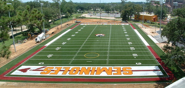
Bill Harkins Field at the Manley R. Whitcomb Band Complex is an artificial turf with rubber fill field built near the Flying High Circus on Chieftain Way.
Bill Harkins, former head coach of the men’s lacrosse team, donated $350,000 towards the construction of the new field in 2005. Previously the space was a grassy field that often alternated between dusty and muddy.
In addition to Lacrosse, the Florida State University Marching Chiefs also practice there along with the football team, who use it as a practice field in anticipation of stadiums with artificial turf.
The stadium contains bleachers, plenty of parking, and is located in the center of campus.
From Atlanta, GA (most direct route; approx. 4.5 hours):
1. Take I-75 South to Exit 99, the Georgia-Florida Parkway (GA HWY 300). Take a Right on Georgia 300 and it`s about 35 miles to US 19 South on the edge of Albany. You take a ight directly after the Miller Brewery, and then there is a limited-access ramp up to US 19. 300 actually continues on 19 and it`s still the GA-FL parkway, so signs should be easy. (Note that 300 and 19 are both four-lane all the way, mostly with a 65 MPH speed limit.)
2. Go 23 miles south on US 19 to Georgia 112 in Camilla. Take a right on Georgia 112 and follow it to Cairo. 112 will turn left going through Camilla, but there are a couple of signs there. This is the first two-lane road you will hit.
3. Georgia 112 will dead-end on HWY 84 just west of Cairo. Take a left, and go to Georgia 93. Take a right on highway 93, and follow it out of town.
4. Georgia 93 will dead-end into 319 13 miles later, just north of the Florida line and JB`s Barbeque. Take a right on 319 S and you`re in Tallahassee about 20 minutes later. When you reach I-10 take I-10W till exit 29 (Monroe St). Then follow directions below.
From the South:
1. Take I-75 North till you hit I-10.
2. Take I-10 west for approximately 100 miles till you hit exit 29, Monroe St.(route 27). Then follow directions below.
From the West:
1. Take I-10 East till you get to Exit 29, Monroe Street (route 27). Then follow directions below.
Directions from I-10:
Take Monroe St. (route 27) for 3.7 miles (or through 17 lights) and on the 18th light make a RIGHT onto Tennessee Street (West Route 90). Go down Tennessee St. for approximately 1 mile and make a LEFT onto Copeland St.
Once on Copeland, make a RIGHT onto Pensacola. Pensacola will dead end at Champions Way in front of Doak Campbell Stadium (FSU Football Stadium). Make a RIGHT onto Champions Way. Turn RIGHT into the parking lot just past the FSU Circus (directly across the street from the Howser Baseball Park). The field is located next to the parking lot.